The photos below are in reverse order.
We set off from the shore right in front of the Dock Cafe in downtown Stillwater as those enjoying their lunch inside watched. It was 11 degrees, sun brightly shining.
We headed south in an attempt to run down to "those ice fishing houses down there." After a few minutes, we decided to run south for 20 minutes, and then turn back.
There was open water along the side of the docked cruise ship. We stayed away from there and headed to the middle of the river to find a snow mobile trail. It was here that Marty's foot went through the top layer of snow into slushy water. We noticed that the wind was at our back and decided we would do well to turn around at 10 minutes, run to the lift bridge and go north for 10 minutes so that last part of our run would be warmer.
The run to the lift bridge was cold. We jumped up on land and ran under the lift bridge on the MN side as the ice directly under the lift bridge looked compromised from the road salt falling from the road above.
We only ran 7 minutes north. It was too cold. We turned back, ran into Stillwater and sat in a little coffee shop and drank coffee and allowed my water tube to thaw.
I left Marty at the van and headed back north of the bridge in an attempt to run up the river and get in 9 miles.
The wind was brutal. I blew back the water from the supply tube into the bladder so that the supply tube wouldn't freeze. This worked the entire trip, except that once the valve froze.
Just south of the boom site, two small planes flew over at about 200 feet. I could see the person inside waving. My glasses kept fogging up as my breath came up and over the face mask. If I exhaled sharply, the warm air would go straight out and not fog up the glasses. I needed the glasses on to cut the wind and the blinding sunlight off the white landscape.
It is quite a thing to recognize the river from our annual St. Croix River Family Pontoon Up The River Day.
I had decided that I did not want to jump off the river at the Boom Site, because that would mean running up the highway to get home. Instead, I'd look for a good place to get off the river further up. In the end, further up meant 7 miles up the river at Arcola Mills.
Near the Boom Site, there is a beautiful ice fall in the WI side of the river. From the highway, it appears quite mundane. I ran over to it. It is a good climb to the bottom of the fall. Then looking up, it is one of the most astounding things I've seen. Ice as thick as a suburban, hanging from the top of a cliff nearly 80 feet above. Water was falling down from the top in dozen of places, and as it landed on the ice below, it froze. The ice was the blue/green color of water that once see in high mountains. I saw water this color in Switzerland once.
Further up the river, I spotted the rope swing that the kids and I swing from on out pontoon trips. Then, through the old limestone bridge footings and on up to the high bridge. It was here that My legs began to complain of being tired.
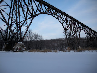
The high bridge is an incredible structure. Probably 100 feet above the river, with spans of at least 100 feet. All iron. Where the sections meet at the tops, they do not connect except for the train track on them. From the river below, it looks like about 2 feet of sky can be seen between sections. Since boats from downstream cannot pass under the bridge due to zebra muscles, I don't think many people actually look up at the bridge from directly beneath.
North of the bridge, I began to wonder if I'd missed Arcola Mills. My iPhone confirmed that I had not. However, there was open water all along the MN shoreline as I continued up the river. I think the river is shallower and runs faster in this section. Finally, the stately white and green mansion of Arcola Mills came into view. I gingerly stepped on a section of ice between two open sections and stepped onto solid ground after nearly three hours on the river. From here, it was only 2.7 miles down Highway 95 to home.
 Looking to MN side. Absolutely stunning. I can understand why people cross this bridge.
 High Bridge.
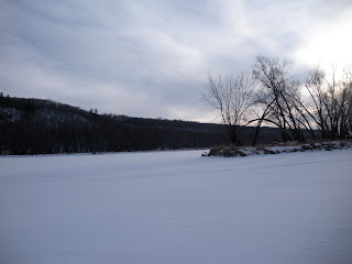
 The WI side.
 The rope swing on the MN side, about 1/2 mile south of the old bridge footings.
 Turkey tracks crossing the river.
 About a mile norht of the Boom Site, looking south.
 Can you see the water dripping down?
 Directly underneath the ice falls. THe long ice strand is actually a climbing rope.
 Ice Falls across from the Boom Site.
 The cliffs of the Boom Site. notice the large house on the hill.
 Looking north toward the Boom Site from an island.
 A short excursion onto one of the many river islands.
 Me and my Spiderman mask heading north up the River.
 North of town. Notice the snowmobile trail and our footprints
 Me and Stillwater in the background, from north of town.
 Coming back to Stillwater from the south.
 Marty just south of the lift bridge, safely far away from the open water.
2 comments:
great pics
good luck in the new year
Thanks for the ride! I remember those places from a warmer river.
Post a Comment